The grading of the wetlands and uplands was completed in October 2017 by 4M Construction. 350,000 cubic yards of soil was excavated from the wetlands to create 53 acres of wetland and transitional habitat. The specific details are: 4 acres of sub tidal habitat, 9 acres of mud and sand flats, 14 acres of salt marsh, 20 acres of high marsh and transitional habitat, 1 acre of riparian, 2 acres of brackish marsh, 3.3 acres of seasonal and vernal ponds. Upland habitats will include 28 acres of native grassland, 25 acres of coastal sage scrub and several acres of sandy annual and back dune swale habitat.
As of November, 2017, nine acres of salt marsh and three acres of upland habitat had been planted with locally sourced native plants. An additional four acres has been drill seeded with Stipa pulchra, a native bunch grass known as purple needle grass.
In addition to wetland and plant communities, multiple habitat enhancement features were incorporated including horizontally and vertically placed logs, to be used as perches, and subterranean hibernaculum to support reptiles and rodents.
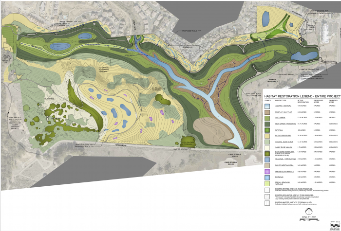
Habitat Map
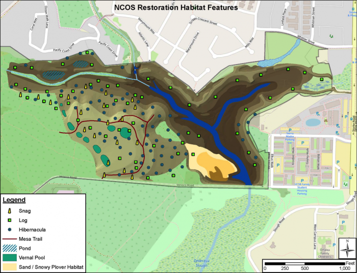
Habitat Enhancement Feature Map
Bridges and trail surfaces are being installed by Granite Construction December 2017 - June 2018. This will include 2 free span pre-fabricated steel bridges, a wooden boardwalk and a culverted concrete crossing. These are visible in the map below.
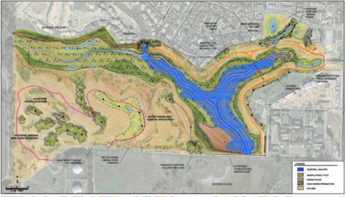
North Campus Open Space Habitat Restoration Map
We hope to construct the visitor's plaza and interpretive trailhead during the late summer 2018 and to open the site to the public at the end of the 2018 summer. In the meanwhile you can learn about fun details about the restoration and other opportunities for tours and more by subscribing to the NCOS monthly newsletter. You can also volunteer any day of the week or the second Saturday of each month. Please email ncos@ccber.ucsb.edu for more information, to volunteer, or to contribute to the project.
CCBER is currently looking for supporters for the long-term management of the project for the benefit of the community and for enhancing training and educational opportunities on the site. There are naming opportunities for bridges, trails, boardwalks, benches and more. Please contact us at ncos@ccber.ucsb.edu.
Funding has been provided by:
| Funding Source | Program Source |
| State Coastal Conservancy | USFWS, National Coastal Wetland Conservation Program (3 grants 2011, 2013, 2016) plus SCC funds |
| California Department of Fish and Wildlife | California Climate Investments |
| California Natural Resources Agency | Urban Greening Program: • Another Urban Greening project funded by Proposition 84 to Improve the Sustainability and Livability of California’s Communities • Edmund G. Brown Jr., GOVERNOR • Strategic Growth Council (for signs not text reference) |
| State Coastal Conservancy | City of Santa Barbara El Estero Mitigation Funds and SCC funds ($500,000) |
| Department of Water Resources | Urban Streams Restoration Program and in-kind services from the Land Trust for Santa Barbara County |
| County of Santa Barbara | Flood Control Division |
| Associated Students Coastal Fund | Coastal resource protection and enhancement |
| Goleta West Sanitary District | |
| UCSB | Funds committed to restoration of South Parcel |
| Wildlife Conservation Board | Habitat Enhancement Funds |
| Ocean Protection Council | Proposition 1 |
| California Department of Fish and Wildlife | Proposition 1 |
| State Coastal Conservancy | Proposition 1 |
| Outhwaite Foundation | |
| County of Santa Barbara | Coastal Resource Enhancement Fund “[Project] was [partially] financed by the County of Santa Barbara's Coastal Resource Enhancement Fund (CREF), a partial mitigation of impacts from the following offshore oil and gas projects: Point Arguello, Point Pedernales, and Santa Ynez Unit.” |
| CalTrans | Active Transportation Program |
| Goleta Valley Land Trust |
NCOS project is currently in the final planning and design phase with permit applications in place, CEQA complete, funding secured and 100% design drawings in review. Pending completion of these steps the first phase of construction will begin in the fall of 2016. Below is a summary of planning actions and links to design documents.
Project Design Progress
Let by the Science Advisory Board (SAB) and the Program committee, formal studies and evaluation of goals and objectives was conducted and a Detailed Project Program (90 page project description; link to document) was prepared, September 2015 and revised December 2015. This document formed the basis for follow-up extended hydrological, geotechnical and soils studies in support of more detailed design parameters. These studies were conducted between December 2015 and May 2016 and supported the development of an interim Basis of Design Report and, in June 2016, 100% detailed design plans including a detailed draft restoration plan.
Environmental Compliance and Outreach
Agencies and the public were formally re-engaged in the project through two meetings, January 15th and February 23rd, respectively. Small group and individual consultations with agencies, environmental groups, native Americans, and the public have been on-going since. The IS/MND was released for public comment in February and certified by the State Clearinghouse on March 29th, 2016. Presentations were also made to public at an Audubon Society Meeting (Oct 18, 2015) and to the Goleta City Council (March 1, 2016). Permit applications are in progress for US Army Corps of Engineers, California Department of Fish and Wildlife, USFWS, Regional Waterboard, Coastal Commission.
Funding
All fundraising for the project has been conducted through formal grant programs intended to support wetland and open space restoration and conservation projects. Notification of intent to fund has been received from the following agencies for funding totaling sufficient for design and restoration of the majority of the 136 acre project: California Natural Resources Agency Urban Greening Program, Department of Water Resources Urban Streams Program, USFWS National Coastal Wetland Conservation Grant program, State Coastal Conservancy, California Department of Fish and Wildlife Proposition 1 and Greenhouse Gas Sequestration programs; the Wildlife Conservation Board, Ocean Protection Council and CalTrans Active Transportation Program. In addition, the following additional groups and agencies have contributed funds to support planning and design work: Goleta Valley Land Trust, USFWS Coastal Program, City of Santa Barbara, County of Santa Barbara, Goleta West Sanitary District, Associated Students Coastal Fund, County Resource Enhancement Fund, and the Land Trust for Santa Barbara County. See Partners page for logos of all agencies.
In June 2014, The Trust for Public Land conducted an online survey as a continuation of a community planning process initiated the preceding year for the Concept Design of the North Campus Open Space. As a result of this survey and overall planning process, clear community priorities have been established for passive recreation amenities, trail features, trail routes, education and interpretive amenities and other site amenities.
Survey Highlights
- 84% of those surveyed currently use the North Campus Open Space
- 38% live within a 10-minute walk of the North Campus Open Space
- The majority of respondents report wanting the design of the property to provide opportunities for wildlife viewing, experiencing and learning about nature, and trails for recreation.
- Respondents also strongly expressed a desire for trails to be adequately developed as a larger system, connected to other existing trails and surrounding roads.
- The most preferred design concept was the one focused on ecology (Concept 1) followed by the multi-functional concept (Concept 3). This seemingly split preference reflects the community priority for a simple site design that optimizes the site’s restoration potential while also sufficiently accommodating the need for access and amenities.
Over 260 people responded to the survey, and while it was primarily online-based, additional responses sent via email or comment letter were accepted. The Trust for Public Land has combined survey comments on the draft concepts with the constraints of the site conditions and University priorities to create a conceptual rendering. Please note that this rendering is a reflection of people’s public access preferences and site constraints, and is conceptual in nature and should not be taken literally.
The trail locations and design of the open space will be further developed in the next phases of the project by UC Santa Barbara. The next steps are to formally consider an array of alternative designs through the campus North Campus Open Space project committee and to evaluate those alternatives through the environmental planning process known as CEQA which will include several opportunities for community input. Funding is being raised primarily through grants.
University Focus Group #1: Tuesday, June 4th 11:30 am - 1:00 pm
Community Workshop #1: Saturday, July 13th 10:00 am - 12:30 pm
Community Workshop #2: Wednesday, August 7th 5:00 pm - 7:30 pm
Community Workshop #3: Wednesday, September 25th 5:00 pm - 7:30 pm
The Trust for Public Land and UC Santa Barbara have been reaching out to the community to solicit input for the North Campus Open Space project.
In all, we distributed over 3,000 leaflets to residents and contacted 20,000 university students, staff and faculty. These efforts attracted 200 participants at three design workshops and one university focus group. Approximately 300 students and faculty also responded to an online survey.
Lively community design workshops and a focus group were designed to provide a broad cross-section of input about neighbors' perspectives regarding site access, site use, and maintenance in the context of the ecological restoration goals.
Participants were given an overview of the site, project scope, and development history before being divided into small groups to go on a site tour and participate in open-format brainstorming sessions. Each group compiled a list of their top priorities and features and presented them to everyone. Common themes were accessibility and connectivity, interpretive signage, neighborhood buffers, wildlife habitat, well-chosen vegetation, and preserving views. The results of the workshops are being incorporated into alternative concept plans and will be made public in 2014.